The SS Republic’s archaeological excavation (conducted by Odyssey Marine Exploration) was the first of its kind ever performed at 518 meters below the ocean’s surface accomplished entirely using advanced robotics.
Computer models combined with information from newspapers and survivors’ reports, ships' logs and other information about currents and the storm were used to establish the target area. The search for the wreck included an exhaustive operation using side-scan sonar and magnetometer technology covering over 1,000 square miles and identifying 24 targets in 2002 and 2003.
During the summer of 2003, a side-scan sonar image revealed a promising target with two paddlewheels, a walking beam engine towering above the seabed, two boilers and a decayed wooden hull. These features and their dimensions very closely matched those of the Republic as documented historically.
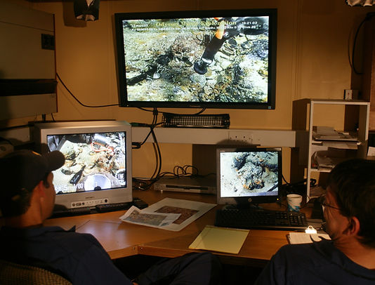
At a depth well beyond a range practical and safe for human divers, the archaeological excavation of the Republic called for adaptations and innovations in the use of Remotely-Operated Vehicles (ROVs) combined with advanced electronic survey/navigation systems, video and still photography and data logging programs to record and process information.
A primary archaeological objective of the project was to verify the storm damage to the ship as chronicled in historical reports derived largely from the survivors’ accounts. These narratives speak of the ship’s paddle boxes and bulwarks washing away, cargo being thrown overboard, and the deck house floating away in the last moments before the ship sank.
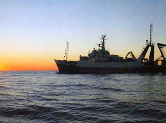
To conduct the excavation, the now retired 251-foot RV Odyssey Explorer was re-fitted to serve as the archaeological platform for the operation. The ship was equipped with an ROV system and with specialized components and technological systems to support archaeology, data logging, and first-aid conservation of recovered artifacts.
The archaeological investigation and excavation of the shipwreck was conducted in two phases: Phase One: the pre-disturbance survey, and Phase Two: the excavation.
The pre-disturbance survey included creating photomosaics of the wreck site and the debris field from thousands of images captured by cameras mounted on the ROV. The final photomosaic of the Republic contained approximately 2,500 high-resolution images each digitally stitched together resulting in a large panoramic view of the entire wreck site.
The initial ROV surveys conducted during Phase One determined that the surface features of the site consisted of a wreck lying relatively upright with the metal framework of both paddlewheels slightly canted outwards. The bow area was flat with no structures rising more than one meter above the seabed. Further evidence at the site suggests the vessel may have landed on the seabed on her starboard bow. Lying off the port bow partially buried was the ship’s bell which was subsequently recovered to positively identify the shipwreck as that of the Republic.
Scattered around the bow area were broken and displaced sections of hull timbers and framing as well as remains of the ship’s deck planking. Overall, the wreck was observed to be in a poor state of preservation, affected by the topography of the seabed, exposure to the elements, accretion and scouring by the strong current and the movement of sediments.
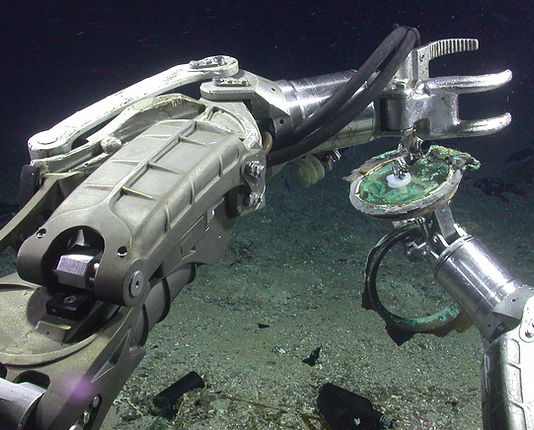
Retrieval of delicate artifacts was achieved with the use of a soft silicone rubber limpet suction device. Fitted to the port manipulator arm of the ROV and powered by the Venturi pump, the limpet suction attachment permits fragile objects—some as small as buttons and coins—to be recovered from the ocean floor without damage or marking.
Most artifacts were recovered when the ROV was either position on the seabed in ‘archaeological sterile’ areas, which would not disturb any artifacts or hull remains, or within areas of dense wreckage hovering above the site to protects its remains.
Artifacts, structural remains, and other objects of interest collected from the site were placed in numbered plastic containers of an appropriate size to securely house the materials recovered. All containers were designed to cope with the effects of varying pressure, depth, and temperature to ensure the contents safe journey to the surface. When filled, the artifact containers were placed in a large rubber-lined metal lifting basket on the seabed, subdivided to store several plastic containers. Each container and division location was numbered, video recorded and entered into the DataLog™ system.
Once the artifacts were lifted to the surface, the artifacts' dimensions and level of preservation were manually recorded on finds sheets and then logged onto a spreadsheet for tracking. Prior to first-aid conservation, the artifacts were photographed on board the recovery vessel, and a separate photo log and file were created. With the sub-sea and surface recording systems, plus a separate inventory and management database maintained by the conservator.
In all 262 ROV dives took place on the site and approximately 3,500 hours were spent on the ocean floor investigating the site. Some 16,000 digital still photographs were captured and over 3,000 hours of video footage was recorded.
The excavation was concluded with success in early 2005, after the retrieval of nearly 14,000 artifacts and over 51,000 gold and silver coins, supported by extensive documentation and recording of the entire process.
In depth details about the Republic excavation can be found in the archaeological reports published on the wreck. The project was also the subject of a National Geographic one-hour special entitled "Civil War Gold" which aired nationally on PBS; an episode of "National Geographic: Ultimate Explorer"; National Geographic Magazine's September 2004 issue; two books "Lost Gold of the Republic" and "Bottles from the Deep"; and numerous television, newspaper and magazine stories.